Edmonton Real Estate Drone Video: Pricing & Permits
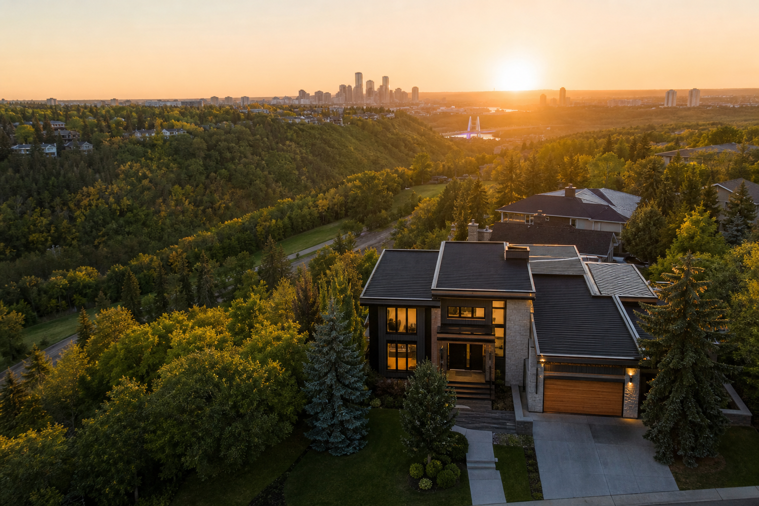
An Edmonton acreage can look ordinary from the driveway. Send a drone above the tree line, however, and the story changes: the house gains scale, the outbuildings make sense, and the route into the city becomes visible. The same transformation happens with a river valley condo, an infill near Whyte Avenue or a new-build home at the edge of Edmonton. Drone video does more than show a roof—it gives buyers the location context they cannot get from interior photography.
That context is especially valuable in a market shaped by ravines, mature neighbourhoods, expanding suburbs and large rural properties. This guide explains typical 2026 Edmonton real estate drone video prices, the flight rules that can affect a shoot and the shots most likely to strengthen a listing.
Edmonton real estate drone video pricing in 2026
Most Edmonton providers price drone coverage as an add-on to photography or a complete listing-video package. The final cost depends on travel, airspace, property size, editing complexity and whether the realtor needs horizontal, vertical or both formats.
| Service | Typical Edmonton price | Common deliverables |
|---|---|---|
| Drone photo add-on | $125–$250 | 5–15 edited aerial images |
| Drone video add-on | $175–$350 | Several aerial clips added to a listing video |
| Drone-only property video | $300–$650 | 30–90-second edited aerial film |
| Photo, video and drone package | $500–$1,200 | Interior photos, walkthrough video and aerial media |
| Luxury or acreage production | $900–$2,000+ | Extended filming, advanced editing and multiple formats |
These are general Canadian-dollar market ranges rather than fixed quotes. A straightforward suburban shoot may remain near the lower end. An acreage outside Edmonton could cost more because of travel, a larger flight area and the time required to capture access roads, land boundaries and secondary structures.
Ask whether a quote includes licensed music, colour grading, address graphics, brokerage branding and a vertical social edit. These items are sometimes included in premium packages but billed separately in entry-level options.
When Edmonton listings benefit most from drone video
Drone footage should answer a buyer’s question, not simply add spectacle. In Edmonton, the strongest use cases are properties where location, land or surrounding amenities influence value.
- River valley and ravine properties: Reveal proximity to trails, green space and natural terrain without making unsupported walking-time claims.
- Acreages and estate homes: Show parcel scale, driveways, shops, barns, landscaping and the relationship between structures.
- New suburban developments: Establish the home’s position near schools, parks, retail areas and developing road connections.
- Urban infill and condos: Connect the property to neighbourhood character, downtown views or nearby commercial districts.
- Commercial and development land: Document access points, adjacent roads and the broader site layout.
A typical detached home on a uniform street may only need two or three aerial clips. That restraint often produces a better video than an extended sequence that repeats the same information.
Drone permits and flight rules in Edmonton
Real estate drone work in Edmonton is governed primarily by Transport Canada’s Remotely Piloted Aircraft System rules. Drones weighing 250 grams or more generally must be registered, and the pilot must hold the certificate required for the planned operation. Basic operations and Advanced operations have different distance, airspace and operating requirements.
Parts of the Edmonton region may fall within controlled or restricted airspace influenced by airports, heliports and military or aviation activity. Depending on the address and flight plan, an operator may need an Advanced Pilot Certificate and authorization through the applicable air navigation process. A professional should verify the site using current official airspace tools before confirming the shoot.
Does every Edmonton shoot require a permit?
No single municipal permit applies automatically to every private-property listing. Requirements depend on where the drone will launch, land and fly. A pilot may need property-owner permission, airspace authorization or approval to operate from certain City-owned locations. Parks, events and managed public spaces can have separate rules.
Using a sub-250-gram drone does not create a universal exemption. Microdrone pilots must still avoid reckless or negligent operation, respect restricted airspace and protect people on the ground. Privacy, safety and local property rules also remain relevant.
What should a realtor confirm?
- The operator carries appropriate commercial liability insurance.
- The aircraft is registered when required.
- The pilot has checked current airspace and authorization requirements.
- The flight can maintain visual line of sight and safe separation.
- The plan avoids unnecessary filming of neighbours, traffic and private areas.
- Weather and wind limits are built into the scheduling policy.
Shot ideas that work in Edmonton
The river valley reveal
Begin near the home, then rise or move laterally to reveal trees, ravines or the North Saskatchewan River corridor. This shot works best when the landscape is genuinely relevant and should not imply direct access that does not exist.
The neighbourhood-to-home approach
Start with a broad view and move toward the property, helping buyers understand street pattern and lot placement. In newer communities, this can establish proximity to parks or open space more clearly than a ground-level shot.
The acreage boundary story
Combine a high establishing view with lower passes along the driveway and around major structures. Approximate boundary graphics can be added in editing, but they should be identified as illustrative and verified against official documents.
The four-season exterior
Edmonton’s seasons can shape presentation. Fresh snow may create a polished winter look, while summer provides longer shooting windows and greener landscapes. Cold temperatures reduce battery performance, so winter productions may require extra batteries, shorter flights and flexible scheduling.
The vertical social opener
A five-to-eight-second rise from the front elevation to a skyline or neighbourhood view can open an Instagram Reel effectively. Another option is a top-down transition that cuts into the interior walkthrough. Capture vertical framing intentionally rather than relying only on a tight crop from horizontal footage.
Frequently asked questions
How long does an Edmonton drone shoot take?
Simple aerial coverage often takes 20–40 minutes on site. Acreages, luxury listings and productions requiring several flight positions may need one to two hours, excluding interior media.
Can a drone fly in winter?
Often, yes, when visibility, temperature, wind and manufacturer limits permit safe operation. Snowfall, icing and strong winds can delay a flight even when the home itself is ready.
Is drone video worth it for every listing?
No. It is most valuable when the aerial view communicates a meaningful selling point. For other homes, the budget may deliver more value through twilight photography, a floor plan or a short vertical walkthrough.
Planning an Edmonton listing that needs clear, cinematic aerial context? Book Melon Media to discuss the property, airspace considerations and the right photo, video and drone package.
Further reading
- Vancouver Video Production Pricing: What Businesses Pay in 2026
- Toronto Real Estate Drone Photography: 2026 Costs, Rules and Listing Benefits
- Real Estate Video Pricing in Canada: 2026 Guide
Further reading
Ready to tell your story on camera?
Cinematic video production with 48–72h delivery, across Canada.